April 15, 2013
Water Data for the Nation (waterdata.usgs.gov)
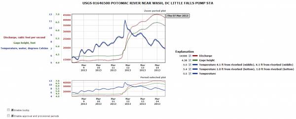
- New plot multiple parameters for a site features dynamic graphs
- Data for up to three parameters for a site can now be plotted on the same graph. For example, you could compare streamflow, gage height and water temperature for the same site on the same graph. This new feature works with both instantaneous values and daily values data. It is accessible as a new output format on a station page.
- Simply pick up to three available parameters then pick the "Graph w/ (up to) 3 parms" radio button, such as discharge, gage height and water temperature. You may also choose a different data range than the default, which is the most recent seven days.

- This new feature also introduces a new graphic format for the site. These graphs are dynamic graphs, created in your browser instead of downloaded as a static image.
- You can turn on or off parameters of interest and these features will appear or disappear from the graph instantly. No page refresh is needed.
- You can narrow or expand the time range of interest in the graphing window by dragging your mouse over the period of interest in the graph.
- Tool tips and provisional data periods can be dynamically enabled and disabled
- A full tutorial will be published soon.
- Bug fixes
- Fixed social media message that occured only in Firefox when date range exceeded most recent 120 days. (PR 28385)
- Latitude/longitude input box now allows latitudes or longitudes to be one or two characters. (PR 28616)
- On station pages, if you enter a start or end date, these dates are remembered when the page is subsequently refreshed, rather than reverting to the default. (PR 29418)
- Discrete measurements now appear on tab-separated (RDB) output for Guam and Hawaiian sites (PR 28999)
- New parameters
- 51185 - Nitrate, water, unfiltered, field, milligrams per liter
- 51186 - Inorganic nitrogen, water, dissolved, calculated as NH3+NO2+NO3, milligrams per liter as nitrogen
- 51187 - Inorganic nitrogen, water, dissolved, calculated as NH3+NO2+NO3, tons per day as nitrogen
- 72223 - Soil water matric potential, bars
- 72224 - Extinction reference absorbance, absorbance units per centimeter
- 72225 - Extinction measurement absorbance, absorbance units per centimeter
- 80297 - Suspended sediment load, water, unfiltered, computed
- 91061 - Nitrate plus nitrite, water, dissolved, pounds per day as nitrogen
- 99133 - NO3+NO2,water,insitu
- 99404 - Chloride, wf, estimated
- 99064 - Water surface elevation difference between two locations, feet
- Fixed some missing or incorrect links on the output formats page (PR 28818)
- Added wireline measurement to the water level method codes. (PR 29546)
Mapper (maps.waterdata.usgs.gov)
- When downloading data in Keyhole Markup Language (KML), a .kml file suffix is used instead of a .xml suffix. This makes these files more likely to open in geographic-based applications such as Google Earth. (PR 28819)
Water Services (waterservices.usgs.gov)
- The number of parameters codes supported by the groundwater levels web service has been increased from five to eleven. This change better supports new vertical datums that are in the Pacific. (PR 29894). The new parameter codes are:
- 72226 - Groundwater level above American Samoa Datum of 1962 (retired in 2001), feet
- 72227 - Groundwater level above American Samoa Vertical Datum of 2002, feet
- 72228 - Groundwater level above Guam Vertical Datum of 1963 (retired in 2003), feet
- 72229 - Groundwater level above Guam Vertical Datum of 2004, feet
- 72230 - Groundwater level above Local Hawaiian Datum, feet
- 72231 - Groundwater level above Northern Marianas Vertical Datum of 2003, feet)
- Clarified documentation to state that there are millions of groundwater levels, not millions of groundwater sites (PR 28795)
- Added a link to the groundwater levels service description on the site's main page. (PR 28800)