Navigating USGS Water Data for the Nation
How to navigate the USGS Water Data for the Nation Site
Navigation Help
Site navigation
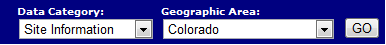
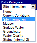
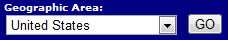
There is a navigation banner at the top of every screen. This banner allows you to jump to various data category pages for different geographical areas. It's as simple as 1, 2, 3 to use this banner:
- Click on the Data Category dropdown and choose a category.
- Click on geographic area drop down and choose an area.
- Now click on the GO button to the new page.
|
|
Web Site Overview
To explore this system follow the 1,2, 3 rule.
- Choose your geographic area
- Choose your data type
- Choose your options
If you are interested in information for one station, be sure to choose just that single station. Then follow the directions in the station navigation section below.
To view the various data available simply click in the box to choose which data you would like to view, then hit GO.

The following table shows what types of data could be available for a site. Depending upon which site you select you could see some of these selections.
| Data type | Description |
|---|---|
| Location Map | The site is showed centered on a map |
| Time-series: Current/Historical Observations | Current and historical data transmitted from the site |
| Time-series: Daily data | Official daily data values for the period of record |
| Time-series: Daily statistics | Daily value statistics for each day of the year |
| Time-series: Monthly statistics | Monthly value statistics for each month of the year |
| Time-series: Annual statistics | Annual value statistics for every year of record |
| Surface-water: Peak streamflow | Highest annual streamflows for a site |
| Surface-water: Measurements | List of all streamflow measurements made at the site |
| Groundwater: Daily data | Official daily values for the period of record |
| Groundwater: Daily data statistics | Daily value statistics for each day of the year |
| Groundwater: Monthly data statistics | Monthly value statistics for each month of the year |
| Groundwater: Annual data statistics | Annual value statistics for every year of record |
| Groundwater: Field measurements | Water level information for a well |
| Water-Quality: Daily data | Official daily values for the period of record |
| Water-Quality: Daily data statistics | Daily value statistics for each day of the year |
| Water-Quality: Monthly data statistics | Monthly value statistics for each month of the year |
| Water-Quality: Annual data statistics | Annual value statistics for every year of record |
| Water-Quality: Field/Lab samples | All water quality data taken from the site |
| Offsite: USGS GroundwaterWatch | USGS GroundwaterWatch pages providing groundwater level data from wells currently in a regular measurement program. |
| Offsite: USGS Annual water-data reports | USGS Annual Water Data Reports providing an archive of the annually published data |
| Offsite: EPA Surf your watershed | EPA site for water quality information in the associated watershed |
| Internal: Sitefile review | Only accessible in the USGS network |