What is my watershed address and how will it help me find USGS data? (or What is a Hydrologic Unit?)
|
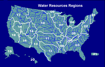
In the United States, watersheds have been numbered since the 1970's using an 8-digit system known as a Hydrologic Unit Code (HUC). This system provides what is essentially a watershed address, and in many cases provides a convenient way to locate USGS water data for your area of interest. In addition to a number, a formal name is also assigned to each HUC, but it is important to be aware that formal names can sometimes differ from a name used locally. For example, Hydrologic Unit number 02080206 is named the Lower James, for the downstream part of the James River watershed in Virginia. The first 2-digits of the code indicate that the Hydrologic Unit is part of the Mid Atlantic Region, as shown on the map below. USGS Water Data for the Nation can be searched using either the 2-digit HUC or the 8-digit HUC for regional and local perspectives.
To find a HUC for your area of interest, follow these steps: Step 1Go to the Watersheds web page at https://www.epa.gov/waterdata/surf-your-watershed. (this link opens in a new window). Step 2Enter a Zip Code to Find Your Watershed, or use any of the other search options provided by the More info link. Step 3Make a note of the watershed name and your 8-digit HUC number--this number will enable you to quickly locate USGS water data for your area of interest. |
Reference: Seaber, P.R., Kapinos, F.P., and Knapp, G.L., 1987, Hydrologic Unit Maps: U.S. Geological Survey Water-Supply Paper 2294, 63 p.