Do site numbers have any particular meaning?
The USGS creates a unique station (site) number to distinguish a site from other locations where hydrological data is collected. This article describes the nomenclature used in establishing site numbers.
Surface water sites
Stations are assigned numbers according to a downstream order system. In assigning station numbers in downstream order, no distinction is made between partial-record stations and other stations; therefore, the station number for a partial-record station indicates downstream-order position in a list made up of both types of stations. Gaps are left in the series of numbers to allow for new stations that may be established; hence, the numbers are not consecutive. An eight-digit number for a station, such as 03171000 includes the two-digit part number "03" plus the six-digit downstream-order number "171000." The part number is derived from Water Supply Paper (WSP) publication volumes or "Parts" and designates the major river basin; for example, part "03" is the Ohio, Cumberland, and Tennessee River Basins. In areas of high station density, more than eight digits may be used for a station number.
The following is a summary table of the Part numbers and the associated areas:
01 North Atlantic slope basins
02 South Atlantic slope basins
03 Ohio, Cumberland, and Tennessee River basins
04 St. Lawrence River basin
05 Hudson Bay and Upper Mississippi River basin
06 Missouri River basin
07 Lower Mississippi River basin
08 Western Gulf of Mexico basins
09 Colorado River basin
10 The Great Basin
11 Pacific slope basins in California
12 Pacific slope basins in Washington and upper Columbia River basin
13 Snake River basin
14 Pacific slope basins in Oregon and lower Columbia River basin
15 Alaska
16 Hawaii
Further detail regarding downstream order number can be found in multiple USGS documents, the most comprehensive being in WSPs 1721 through 1740. For example, page one of WSP 1722 the Description of Data section contains a verbose description. A PDF version of that document can be found here.
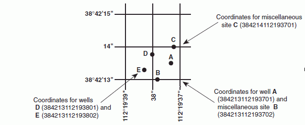
Wells and miscellaneous sites
The USGS well system is based on the grid system of latitude and longitude. The system provides the geographic location of the well and a unique number for each site. The number consists of 15 digits. The first 6 digits denote the degrees, minutes, and seconds of latitude, and the next 7 digits denote degrees, minutes, and seconds of longitude; the last 2 digits are a sequential number for wells within a 1-second grid. In the event that the latitude-longitude coordinates for a well are the same, a sequential number such as “01,” “02,” and so forth, would be assigned as one would for wells (see fig. 4). This system may also be used for random water-quality miscellaneous sites. (A local well-numbering system is also used. It is a 2-part identifier, consisting of the abbreviation of county name and the serial number within the county.)
It cannot be emphasized too strongly that the site ID, once assigned, is used as a pure number and has no locational significance beyond representing the best location available at the time the site ID was assigned. The latitude and longitude fields for the site should be used for the site's location.